Map styling
The look and feel of a SDK MapView can be fully customized. You can choose to set the colors via a global configuration file or you can load map designs dynamically for day and night mode.
Dynamically load map designs
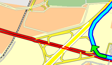
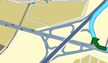
If you want to use your own map colors you can load your own color definition files with MapView.setMapDesign(). Our tutorial comes with some example color definitions for day and night mode.
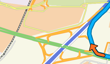
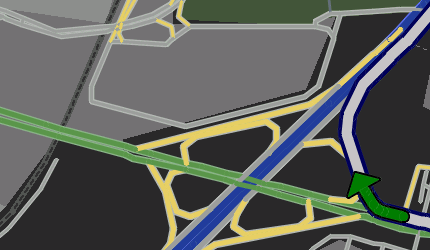
| Karlsruhe_day.ini | Karlsruhe_night.ini |
|---|---|
 |
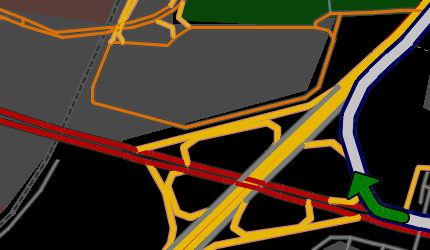 |
| Liverpool_day.ini | Liverpool_night.ini |
|---|---|
 |
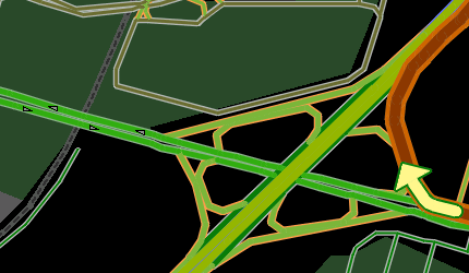 |
| London_day.ini | London_night.ini |
|---|---|
 |
 |
The color definitions are ini files with a [Colors] section and several color parameters. Colors are defined in RGB format, namely r,g,b, where r is red, g is green, and b is blue. r,g,b each take values in the range 0 to 255.
The [Colors] section can define the following parameters:
| Parameter | Description |
|---|---|
| COLMAPBACK | color for the map background |
| COLSTREET0 | color for the outside contour of a motorway |
| COLSTREET1 | color for the outside contour of a national road |
| COLSTREET2 | color for the outside contour of a motorway slip road |
| COLSTREET3 | color for the outside contour of a country road |
| COLSTREET4 | color for the outside contour for a fast urban road |
| COLSTREET5 | color for the outside contour for a normal urban road |
| COLSTREET6 | color for the outside contour of a ferry |
| COLPEDESTRIAN | color for the outside contour of a pedestrian zone/residential area |
| COLSTREET0_INNER | inside color for a motorway |
| COLSTREET1_INNER | inside color for a national road |
| COLSTREET2_INNER | inside color for a motorway slip road |
| COLSTREET3_INNER | inside color for a country road |
| COLSTREET4_INNER | inside color for a fast urban road |
| COLSTREET5_INNER | inside color for a normal urban road |
| COLSTREET6_INNER | inside color for a ferry |
| COLPEDESTRIAN_INNER | inside color for a pedestrian zone/residential area |
| COLROUTEINNER | inside color for a route trace |
| COLROUTEOUTER | outside color for a route trace |
| COLROUTEINNER_TARGETAREA | inside color for a route trace in a target area |
| COLROUTEOUTER_TARGETAREA | outside color for a route trace in a target area |
| COLROUTEINNER_ECOTAXE | inside colorfor a traffic truck toll on-route |
| COLROUTEOUTER_ECOTAXE | outside colorfor a traffic truck toll on-route |
| COLROUTEINNER_TOLL | inside colorfor a traffic toll on-route |
| COLROUTEOUTER_TOLL | outside colorfor a traffic toll on-route |
| COLTMCINNER | inside color for a traffic jam on-route |
| COLTMCOUTER | outside color for a traffic jam on-route |
| COLTMCINNEROFFROUTE | inside color for a traffic jam off-route |
| COLTMCOUTEROFFROUTE | outside color for a traffic jam off-route |
| COLTRUCKERSEGMENTS | color of segments that are restricted for trucks |
| COLMANOVERARROWBACK | shadow color for a maneuver arrow |
| COLMANOVERARROWFORE | color of a maneuver arrow |
| COLWATER | color for a lake, river, see |
| COLURBAN | color for the town area |
| COLINDUSTRY | color for an industrial zone |
| COLWOOD | color for a forrest |
| COLPARK | color for a park |
| COLSKY | color for the sky |
| COLHORIZON | color of the horizont |
Global configuration
The configuration file lies in the data directory you specified in while initializing the SDK and is called „maprenderer.ini“. If this file is not available, default values will be used for all parameters normally included in maprenderer.ini. The following headings will describe the section names for the particular entries.
[Colors_Day] / [Colors_Night]
Colors are defined in RGB format, namely r,g,b, where r is red, g is green, and b is blue. r,g,b each take values in the range 0 to 255. Two sections are included in the file maprenderer.ini: [Colors_Day] for the day view and [Colors_Night] for the night view. Both sections can define the following parameters:
| Parameter | Description |
|---|---|
| COLMAPBACK | color for the map background |
| COLSTREET0 | color for the outside contour of a motorway |
| COLSTREET1 | color for the outside contour of a national road |
| COLSTREET2 | color for the outside contour of a motorway slip road |
| COLSTREET3 | color for the outside contour of a country road |
| COLSTREET4 | color for the outside contour for a fast urban road |
| COLSTREET5 | color for the outside contour for a normal urban road |
| COLSTREET6 | color for the outside contour of a ferry |
| COLPEDESTRIAN | color for the outside contour of a pedestrian zone/residential area |
| COLFORESTROAD | color for a forest road |
| COLSTREET0_INNER | inside color for a motorway |
| COLSTREET1_INNER | inside color for a national road |
| COLSTREET2_INNER | inside color for a motorway slip road |
| COLSTREET3_INNER | inside color for a country road |
| COLSTREET4_INNER | inside color for a fast urban road |
| COLSTREET5_INNER | inside color for a normal urban road |
| COLSTREET6_INNER | inside color for a ferry |
| COLPEDESTRIAN_INNER | inside color for a pedestrian zone/residential area |
| COLFORESTROAD_INNER | inside color for a forest road |
| COLROUTEINNER | inside color for a route trace |
| COLROUTEOUTER | outside color for a route trace |
| COLROUTEINNER_TARGETAREA | inside color for a route trace in a target area |
| COLROUTEOUTER_TARGETAREA | outside color for a route trace in a target area |
| COLTMCINNERONROUTE | inside color for a traffic jam on-route |
| COLTMCOUTERONROUTE | outside color for a traffic jam on-route |
| COLTMCINNEROFFROUTE | inside color for a traffic jam off-route |
| COLTMCOUTEROFFROUTE | outside color for a traffic jam off-route |
| COLMANOVERARROWBACK | shadow color for a manoeuvre arrow |
| COLMANOVERARROWFORE | color of a manoeuvre arrow |
| COLWATER | color for a lake, river, see |
| COLURBAN | color for the town area |
| COLINDUSTRY | color for an industrial zone |
| COLWOOD | color for a forrest |
| COLPARK | color for a park |
| COLSKY | color for the sky |
| COLHORIZON | color of the horizont |
| COLBORDER | color of borders |
| COLTRUCKERSEGMENTS | color of segments that are restricted for trucks |
| COLCCP1 | polygon fill color for some of the CCP’s polygons |
| COLCCP2 | polygon fill color for the remaining polygons of the CCP |
| COLCCPFILL | fill color for the CCP’s surrounding circle |
[Levelling]
Defines upon which zoomlevel the different renderlevels will be shown, and which street categories are shown in the particular level (all values are in merc/pix).
| Parameter | Description |
|---|---|
| Scale1Treshhold | |
| Scale10Threshold | |
| Scale100Threshold |
[3D]
In 3D mode the angle of view will be set by
| Parameter | Description |
|---|---|
| 3DViewAngle |
[Details3D]
The following parameters are used to tune the behaviour of the renderer in 3d mode. Zoom levels can be defined up to which the following three street categories are shown. When this zoom level is reached, the streets with the corresponding category are faded out
| Parameter | Description |
|---|---|
| 3dScaleForMaxCat3 | Specifies the zoom factor up to which all streets are shown. If this zoom factor is exceeded, only streets of category 3 (or lower) are shown. |
| 3dScaleForMaxCat2 | Specifies the zoom factor between when only streets of category 2 (or lower) are shown |
| 3dScaleForMaxCat1 | Specifies the zoom factor between when only streets of category 1 (or lower) are shown |
Restriction: 3dScaleForMaxCat1 > 3dScaleForMaxCat2 > 3dScaleForMaxCat3
A similar mechanism is implemented for the visualization of truck restriction icons
| Parameter | Description |
|---|---|
| 3dScaleForMaxCat3Icons | If the current scale is greater or equal to the specified scale and the street category is greater than three, then no icons are drawn. |
| 3dScaleForMaxCat2Icons | If the current scale is greater or equal to the specified scale and the street category is greater than two, then no icons are drawn. |
| 3dScaleForMaxCat1Icons | If the current scale is greater or equal to the specified scale and the street category is greater than one, then no icons are drawn. |
Restriction: 3dScaleForMaxCat1Icons > 3dScaleForMaxCat2Icons > 3dScaleForMaxCat3Icons
[Details2D]
In 2D mode the following parameter can be configured
| Parameter | Description |
|---|---|
| 2dMaxIconScale | maximum scale for truck restriction icons in 2D mode |
[CCPLook]
The look of the CCP (current car position) can be configured via three parameters
| Parameter | Description |
|---|---|
| ShowSurroundingCircle | Specifies if the surrounding circle should be shown. |
| CircleFillOpacity | Specifies the opacity of the fill color of the surrounding circle. Valid values range from 0 to 31. 0 is opaque, 31 is fully transparent. |
| CCPScaleFactor | Specifies the scale factor of the CCP and its surrounding circle. 100 is original size, 50 is half size, 200 is double size, … |
[Renderer]
General defintions for rendering
| Parameter | Description |
|---|---|
| IncreaseStreetnameLabels | increase the number of streetname labels Valid values are 0: don’t increase, 1: increase (default is 0) |
| EnhanceRenderPerformance | render faster by fading out streets earlier and rendering less details Valid values are 0: render higher details, 1: render less details (default is 1) |
Example
In the example below one can see the default settings in the maprenderer.ini
[Colors_Day]
COLMAPBACK=248,252,192
COLSTREET0=248,0,0
COLSTREET1=0,0,0
COLSTREET2=104,104,104
COLSTREET3=200,120,120
COLSTREET4=128,128,128
COLSTREET5=128,128,128
COLSTREET6=128,128,128
COLPEDESTRIAN=200,220,240
COLSTREET0_INNER=248,252,0
COLSTREET1_INNER=248,0,0
COLSTREET2_INNER=248,244,48
COLSTREET3_INNER=248,244,48
COLSTREET4_INNER=249,249,187
COLSTREET5_INNER=248,252,248
COLSTREET6_INNER=248,252,248
COLPEDESTRIAN_INNER=200,220,240
COLROUTEINNER=0,252,248
COLROUTEOUTER=0,0,248
COLROUTEINNER_TARGETAREA=0,255,0
COLROUTEOUTER_TARGETAREA=0,128,0
COLTMCINNER=248,252,248
COLTMCOUTER=248,4,0
COLTMCINNEROFFROUTE=148,252,248
COLTMCOUTEROFFROUTE=148,4,0
COLMANOVERARROWBACK=0,0,0
COLMANOVERARROWFORE=0,252,0
COLWATER=128,200,232
COLURBAN=248,200,144
COLINDUSTRY=224,228,224
COLWOOD=160,204,144
COLPARK=120,192,48
COLSKY=80,100,248
COLHORIZON=208,212,208
COLTRUCKERSEGMENTS=255,128,0
COLCCP1=255,0,0
COLCCP2=128,0,0
COLCCPFILL=255,255,255

[Colors_Night]
COLMAPBACK=0,0,0
COLSTREET0=176,0,0
COLSTREET1=32,32,32
COLSTREET2=176,0,0
COLSTREET3=200,120,120
COLSTREET4=64,64,64
COLSTREET5=64,64,64
COLSTREET6=64,64,64
COLPEDESTRIAN=96,108,120
COLSTREET0_INNER=224,180,0
COLSTREET1_INNER=176,0,0
COLSTREET2_INNER=224,180,0
COLSTREET3_INNER=224,180,0
COLSTREET4_INNER=216,108,0
COLSTREET5_INNER=120,124,120
COLSTREET6_INNER=120,124,120
COLPEDESTRIAN_INNER=96,108,120
COLROUTEINNER=192,192,192
COLROUTEOUTER=0,0,88
COLROUTEINNER_TARGETAREA=255,0,0
COLROUTEOUTER_TARGETAREA=127,0,0
COLTMCINNER=248,252,248
COLTMCOUTER=248,4,0
COLMANOVERARROWBACK=0,0,0
COLMANOVERARROWFORE=0,124,0
COLWATER=40,68,160
COLURBAN=72,72,72
COLINDUSTRY=128,0,0
COLWOOD=0,80,0
COLPARK=0,88,0
COLSKY=24,112,208
COLHORIZON=176,148,176
COLTRUCKERSEGMENTS=168,84,0
COLCCP1=255,0,0
COLCCP2=128,0,0
COLCCPFILL=255,255,255

[Details3D]
3dScaleForMaxCat3=4.0f
3dScaleForMaxCat2=5.0f
3dScaleForMaxCat1=6.0f
3dScaleForMaxCat3Icons=4.0f
3dScaleForMaxCat2Icons=5.0f
3dScaleForMaxCat1Icons=6.0f

[Details2D]
2dMaxIconScale=5.0f

[CCPLook]
ShowSurroundingCircle=1
CircleFillOpacity=15
CCPScaleFactor=100

[Renderer]
IncreaseStreetnameLabels=0
EnhanceRenderPerformance=1