02 Basic map drawing
Overview
We will learn how to display a simple map and how to connect it with gestures to handle the map.
Base
You can use your results from Tutorial01 as a base for our new project.
Show a map
First open the Main.storyboard and drag a standard view into the ViewController. Make the view fullscreen. Open the Xcode "Identity Inspector" in the right pane and put the class "NSDK_UIMapView" in the field "Custom Class". Ctrl-Drag the view into the file ViewContoller.h to create the following property:
@property (weak, nonatomic) IBOutlet NSDK_UIMapView *uiMapView;
Don't forget to import the SDK Header at the top of the file:
#import "navicoreFramework/NSDK_Navigation.h"
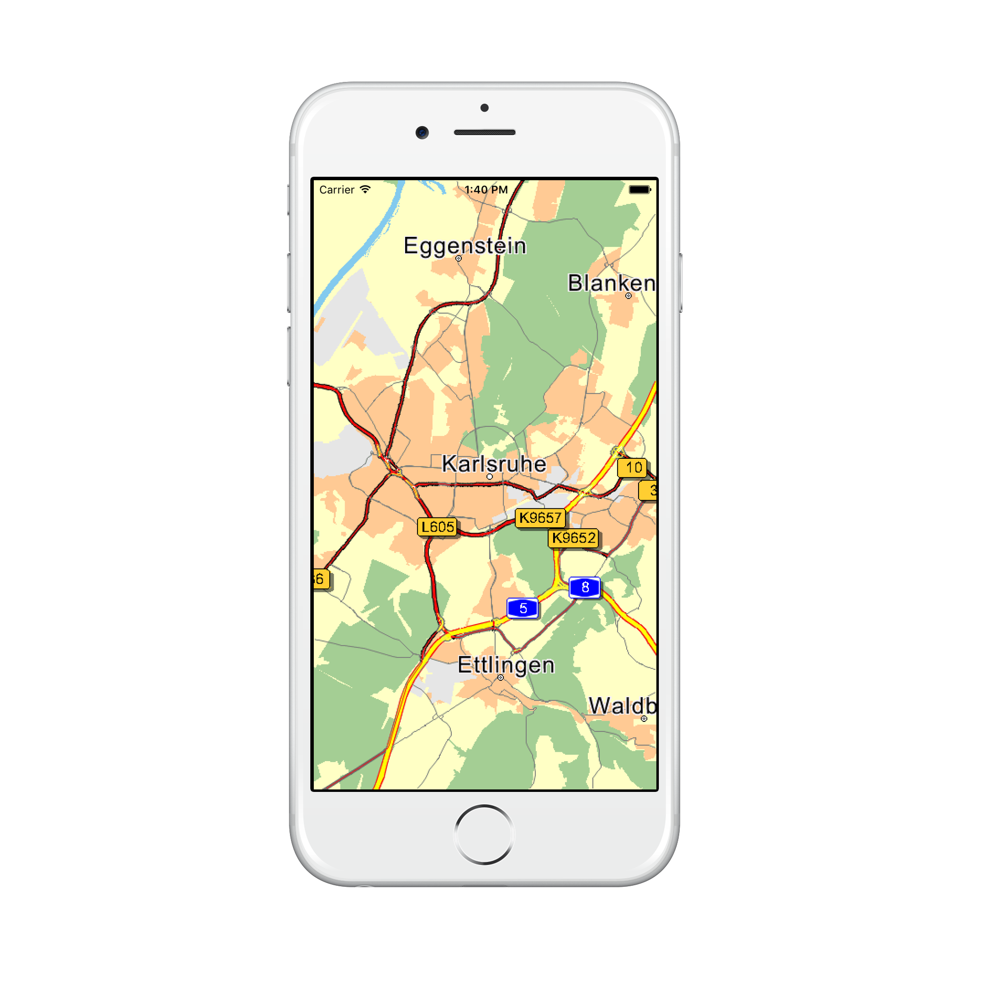
To see an existing part of the map we set an appropriate scale level and the center of the map to Karlsruhe, Germany. Therefore we edit the ViewController.m file:
...
@implementation ViewController

- (void)viewDidLoad {
    [super viewDidLoad];
    [_uiMapView setScale:5000];

    //Mercator coordinates
    NSDK_Position * pos = [[NSDK_Position alloc] initWithX:934177 y:6268747];

    //GPS coordinates
    //NSDK_Position * pos = [[[NSDK_GeoPosition alloc] initWithLatitude:49.005351 longitude:8.401255] toPosition];

    [_uiMapView setCenterWithPosition:pos]; //Karlsruhe, Germany
}
...
Hint
The coordinates are in Mercator format (https://en.wikipedia.org/wiki/Mercator_projection). As you can see in the commented code, you also can use GPS coordinates (World Geodetic System 1984, https://en.wikipedia.org/wiki/World_Geodetic_System)
The running app should look like in this picture:
Customize map colors
If you wan't to use your own map colors you can load your own color definition files with [NSDK_UIMapView setMapDesign:isDay:]. Our tutorial comes with some example color definitions for day and night mode.
@implementation ViewController

- (void)viewDidLoad {
...

    //setMapDesign
    NSBundle *b = [NSBundle mainBundle];
    NSString *dir = [b resourcePath];
    NSString *srcPath = [dir stringByAppendingPathComponent:@"res/data/renderer/London_night.ini"];
    [_uiMapView setMapDesign:srcPath isDay:NO];
    srcPath = [dir stringByAppendingPathComponent:@"res/data/renderer/London_day.ini"];
    [_uiMapView setMapDesign:srcPath isDay:YES];

}
...
The color definitions are ini files with a [Colors] section and several color parameters. Colors are defined in RGB format, namely r,g,b, where r is red, g is green, and b is blue. r,g,b each take values in the range 0 to 255.
The [Colors] section can define the following parameters:
| Parameter | Description |
|---|---|
| COLMAPBACK | color for the map background |
| COLSTREET0 | color for the outside contour of a motorway |
| COLSTREET1 | color for the outside contour of a national road |
| COLSTREET2 | color for the outside contour of a motorway slip road |
| COLSTREET3 | color for the outside contour of a country road |
| COLSTREET4 | color for the outside contour for a fast urban road |
| COLSTREET5 | color for the outside contour for a normal urban road |
| COLSTREET6 | color for the outside contour of a ferry |
| COLPEDESTRIAN | color for the outside contour of a pedestrian zone/residential area |
| COLSTREET0_INNER | inside color for a motorway |
| COLSTREET1_INNER | inside color for a national road |
| COLSTREET2_INNER | inside color for a motorway slip road |
| COLSTREET3_INNER | inside color for a country road |
| COLSTREET4_INNER | inside color for a fast urban road |
| COLSTREET5_INNER | inside color for a normal urban road |
| COLSTREET6_INNER | inside color for a ferry |
| COLPEDESTRIAN_INNER | inside color for a pedestrian zone/residential area |
| COLROUTEINNER | inside color for a route trace |
| COLROUTEOUTER | outside color for a route trace |
| COLROUTEINNER_TARGETAREA | inside color for a route trace in a target area |
| COLROUTEOUTER_TARGETAREA | outside color for a route trace in a target area |
| COLROUTEINNER_ECOTAXE | inside colorfor a traffic truck toll on-route |
| COLROUTEOUTER_ECOTAXE | outside colorfor a traffic truck toll on-route |
| COLROUTEINNER_TOLL | inside colorfor a traffic toll on-route |
| COLROUTEOUTER_TOLL | outside colorfor a traffic toll on-route |
| COLTMCINNER | inside color for a traffic jam on-route |
| COLTMCOUTER | outside color for a traffic jam on-route |
| COLTMCINNEROFFROUTE | inside color for a traffic jam off-route |
| COLTMCOUTEROFFROUTE | outside color for a traffic jam off-route |
| COLTRUCKERSEGMENTS | color of segments that are restricted for trucks |
| COLMANOVERARROWBACK | shadow color for a maneuver arrow |
| COLMANOVERARROWFORE | color of a maneuver arrow |
| COLWATER | color for a lake, river, see |
| COLURBAN | color for the town area |
| COLINDUSTRY | color for an industrial zone |
| COLWOOD | color for a forrest |
| COLPARK | color for a park |
| COLSKY | color for the sky |
| COLHORIZON | color of the horizont |