02 Basic map drawing
Overview
We will learn how to display a simple map and how to connect it with gestures to handle the map.
Base
You can use your results from Tutorial01 as a base for our new project.
Show a map
First open the Main.storyboard and drag a standard view into the ViewController. Make the view fullscreen. Open the Xcode "Identity Inspector" in the right pane and put the class "NSDK_UIMapView" in the field "Custom Class". Ctrl-Drag the view into the file ViewContoller.h to create the following property:
@property (weak, nonatomic) IBOutlet NSDK_UIMapView *uiMapView;
Don't forget to import the SDK header at the top of the file:
#import "navicoreFramework/NSDK_Navigation.h"
To see an existing part of the map, we set an appropriate scale level and the center of the map to Karlsruhe, Germany (PTV headquarter btw.). Therefore we edit the ViewController.m file:
...
@implementation ViewController

- (void)viewDidLoad {
    [super viewDidLoad];

    // check whether an NSDK intialization error occured in 'AppDelegate'
    // and if yes, remove the _uiMapView
    appDelegate = (AppDelegate *)[[UIApplication sharedApplication] delegate];
    if (appDelegate.nsdkStartupError != nil) {
        [_uiMapView removeFromSuperview];
        return;
    }

    [_uiMapView setScale:5000];

    //Mercator coordinates
    NSDK_Position * pos = [[NSDK_Position alloc] initWithX:934177 y:6268747];

    //GPS coordinates
    //NSDK_Position * pos = [[[NSDK_GeoPosition alloc] initWithLatitude:49.005351 longitude:8.401255] toPosition];

    [_uiMapView setCenterWithPosition:pos]; //Karlsruhe, Germany
}

- (void)viewDidAppear:(BOOL)animated {
    [super viewDidAppear:animated];

    // Check whether an NSDK intialization error occured and show it to the user
    if (appDelegate.nsdkStartupError != nil) {
        UIAlertController* alert = [UIAlertController alertControllerWithTitle:@"Navigation Initialization error"
            message:appDelegate.nsdkStartupError.localizedDescription
            preferredStyle:UIAlertControllerStyleAlert];
        [self presentViewController:alert animated:YES completion:nil];
    }
}

...
Hint
The coordinates are in Mercator format (https://en.wikipedia.org/wiki/Mercator_projection). As you can see in the commented code, you can also use GPS coordinates (World Geodetic System 1984, https://en.wikipedia.org/wiki/World_Geodetic_System)
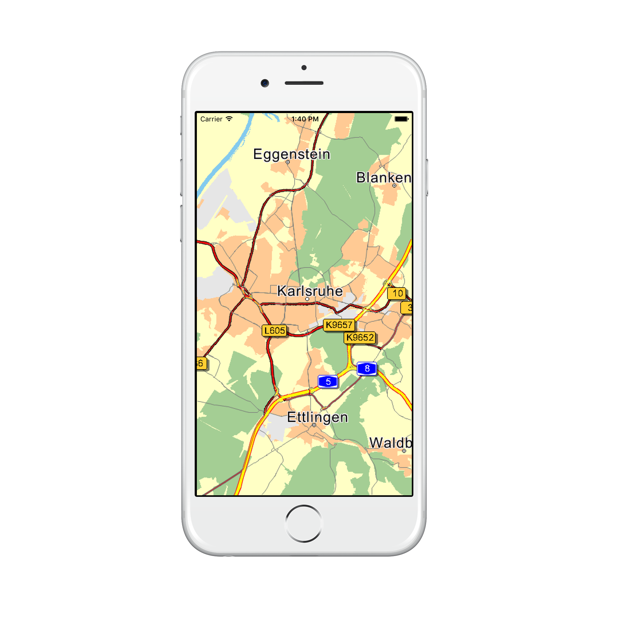
The running app should look like in this picture:
Customize map colors
If you want to use your own map colors, you can load your own color definition files with [NSDK_UIMapView setMapDesign:isDay:]. Our tutorial comes with some example color definitions for day and night mode. We load them by overriding onInitialized method of the NSDK_UIMapView in our custom UIMapView implementation. Do not forget to replace the NSDK_UIMapView class with your custom UIMapView class in the Main.storyboard file.
@implementation UIMapView

- (void) onInitialized {
    NSBundle *b = [NSBundle mainBundle];
    NSString *dir = [b resourcePath];
    NSString *srcPath = [dir stringByAppendingPathComponent:@"res/data/renderer/London_night.ini"];
    [self setMapDesign:srcPath isDay:NO];
    srcPath = [dir stringByAppendingPathComponent:@"res/data/renderer/London_day.ini"];
    [self setMapDesign:srcPath isDay:YES];
}

...
The color definitions are ini files with a [Colors] section and several color parameters. Colors are defined in RGB format, namely r,g,b, where r is red, g is green, and b is blue. r,g,b each take values in the range 0 to 255.
The [Colors] section can define the following parameters:
| Parameter | Description |
|---|---|
| COLMAPBACK | Color for the map background |
| COLSTREET0 | Color for the outside contour of a motorway |
| COLSTREET1 | Color for the outside contour of a national road |
| COLSTREET2 | Color for the outside contour of a motorway slip road |
| COLSTREET3 | Color for the outside contour of a country road |
| COLSTREET4 | Color for the outside contour for a fast urban road |
| COLSTREET5 | Color for the outside contour for a normal urban road |
| COLSTREET6 | Color for the outside contour of a ferry |
| COLPEDESTRIAN | Color for the outside contour of a pedestrian zone/residential area |
| COLSTREET0_INNER | Inside color for a motorway |
| COLSTREET1_INNER | Inside color for a national road |
| COLSTREET2_INNER | Inside color for a motorway slip road |
| COLSTREET3_INNER | Inside color for a country road |
| COLSTREET4_INNER | Inside color for a fast urban road |
| COLSTREET5_INNER | Inside color for a normal urban road |
| COLSTREET6_INNER | Inside color for a ferry |
| COLPEDESTRIAN_INNER | Inside color for a pedestrian zone/residential area |
| COLROUTEINNER | Inside color for a route trace |
| COLROUTEOUTER | Outside color for a route trace |
| COLROUTEINNER_TARGETAREA | Inside color for a route trace in a target area |
| COLROUTEOUTER_TARGETAREA | Outside color for a route trace in a target area |
| COLROUTEINNER_ECOTAXE | Inside colorfor a traffic truck toll on-route |
| COLROUTEOUTER_ECOTAXE | Outside colorfor a traffic truck toll on-route |
| COLROUTEINNER_TOLL | Inside colorfor a traffic toll on-route |
| COLROUTEOUTER_TOLL | Outside colorfor a traffic toll on-route |
| COLTMCINNER | Inside color for a traffic jam on-route |
| COLTMCOUTER | Outside color for a traffic jam on-route |
| COLTMCINNEROFFROUTE | Inside color for a traffic jam off-route |
| COLTMCOUTEROFFROUTE | Outside color for a traffic jam off-route |
| COLTRUCKERSEGMENTS | Color of segments that are restricted for trucks |
| COLMANOVERARROWBACK | Shadow color for a maneuver arrow |
| COLMANOVERARROWFORE | Color of a maneuver arrow |
| COLWATER | Color for a lake, river, sea |
| COLURBAN | Color for the town area |
| COLINDUSTRY | Color for an industrial zone |
| COLWOOD | Color for a forest |
| COLPARK | Color for a park |
| COLSKY | Color for the sky |
| COLHORIZON | Color of the horizon |